One year has elapsed since the successful GEUS expedition to Camp Century to establish instrumentation in the summer of 2017. Three automated instruments were deployed, 175 m of ice core was drilled, and nearly 100 km of ice-penetrating radar imagery was collected on the expedition. This video describes the expedition.
Data from the first year
Ice and climate data are satellite-transmitted from stations on the ice-sheet several times per day and the daily averages are shown in real time online here.
The minimum average daily air temperature measured in the first year of the programme was -47.2°C on 10 March 2018. The maximum average daily air temperature was -0.8°C on 31 July 2017. The average temperature for the first year was -24°C.
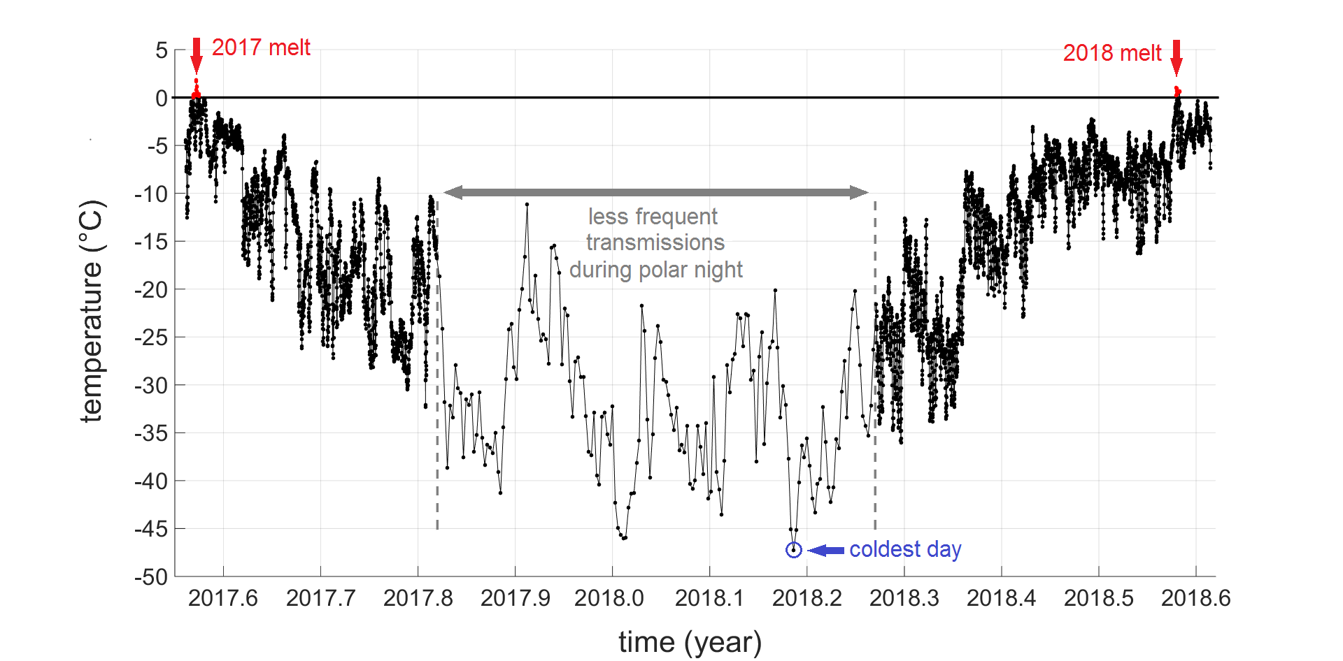
The minimum average daily wind speed measured in the first year of the programme was 0.6 m/s on 31 August 2017. The maximum average daily wind speed was 16.0 m/s on 25 October 2017. The instruments where in complete darkness – polar night – for approximately three and half months. During this time, the solar-powered instruments relied on their battery reserves and transmitted measurements less frequently.
New scientific article
The scientific article Initial field activities of the Camp Century Climate Monitoring Programme in Greenland has been published in the Geological Survey of Denmark and Greenland Bulletin 41 - Review of Survey Activities 2017. Read the article here.
The article documents that surface melt briefly occurred – less than one week – in both summer 2017 and 2018. Additional refrozen melt layers from the past decade are identifiable in the ice cores. When Camp Century was built in 1959, no summer melt occurred at the site.
Plans for 2019 and beyond
The next fieldwork at Camp Century is scheduled for summer 2019. Existing instruments will be raised above the accumulating snow, and a fourth instrument to measure the speed of ice flow will be installed. This year’s maintenance was postponed due to bad weather and logistical issues in Northwest Greenland.
Analysis of radar imagery to map the precise extent and depth of the Camp Century debris field and active layer footprint is ongoing. A complete site map is expected to be published in 2019.
The refined knowledge of the sub-surface debris field and data on the overlying snow and ice will form the basis for modelling of the likelihoods of meltwater interacting with abandoned materials at the Camp Century site over the next century. The first updated preliminary projections based on the new data are expected at the end of 2019. In time, this will lay the foundation for a science-based discussion of the future of Camp Century.